
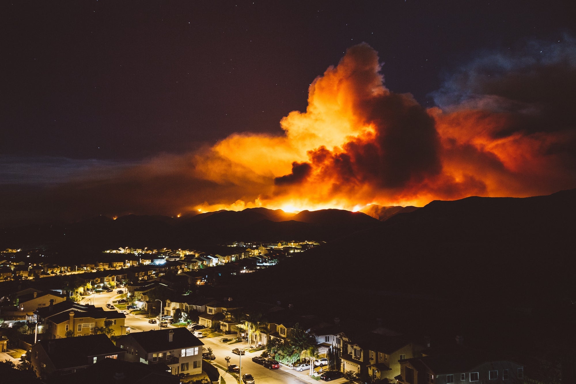
It isn’t just your imagination, wildfires are getting larger, happening more often, and spreading through areas that traditionally don’t see large fires. As the 2025 Eaton Fire in California and the 2021 Marshall Fire in Colorado showed, modern wildfires are a threat to densely populated urban zones as well as rural areas. The Eaton Fire alone destroyed over 9,400 structures and caused an estimated $25 billion dollars worth of damage. In 2023, one of the nation’s deadliest fires spread rapidly across the island of Maui, overwhelming the historic coastal town of Lahaina within just 2 hours. 102 lost their lives.

On top of stronger single fires, regions across the globe are now experiencing multiple fires at once, leading to an alarming new dynamic where separate fires can merge and combine into newly-termed “megafires” that span over 100,000 acres. A recent University of Maryland study found that fires now burn on average twice as much forested territory than they did before the start of the new millenium. 2024 was the worst year for wildfires on record, with both tropical and boreal forests burning on both sides of the equator. It used to be that the high water content in these types of forest prevented large, fast-spreading wildfires, but now Siberia, northern Canada, the Brazilian rainforest, and other historically wet locales are seeing devastating fires each year.
In this post, we’ll examine not only the science behind this disturbing trend, but also how to prepare for the worst to keep yourself and your family safe.
What causes a wildfire? Assessing your own risk Predicting fire weather Preparedness is keyTable of Contents
What causes a wildfire?
Wildfires occur naturally and some ecosystems even depend on them to encourage biodiversity. Many plant species have even adapted to regular fire seasons and incorporate them into their reproductive cycles. Lightning strikes are by far the most common natural causes of wildfires, but volcanic activity, sparks from falling rocks, and natural gas accumulation from composting plant matter can also ignite a fire.
But the modern age has brought a whole host of new ignition sources tied to human activity. Car accidents, downed power lines, improperly extinguished campfires, slash-and-burn farming techniques, and arson can all spark a fire in a remote area. Unlike conventional house or building fires, these ignitions happen outside the rapid response area of a local fire department, or might go unnoticed for those first crucial hours when the fire is still small. Once an uncontrolled fire spreads beyond the point of ignition and begins rapidly moving across the landscape, you’ve got a wildfire on your hands.
Why are they getting stronger?
There are many factors that contribute to the frequency and intensity of wildfires. Any area with lots of dry vegetation clumped close together is at risk of a wildfire, but even large, well-hydrated trees can provide fuel for wildfires if the conditions are right.
On average, the past decades have been trending hotter and drier across the world. Most concerning for wildfire risk, multi-year droughts have become much more common over the past 40 years. Compared to short-term droughts, dry spells that last for years are much harder on plant and animal life, exceeding the natural adaptations that help an ecosystem survive water shortages. A 2025 study found that the global land area affected by long megadroughts grew each year by 50,000 square kilometers; roughly the size of Switzerland. More droughts mean more dead plants, and even those that survive are severely dried out, adding significantly more ready-to-use fuel for an ignition event.

Image source: Envato
The other major factor adding to the wildfire crisis is strong winds. Windstorms can both ignite fires by knocking down power lines as well as help spread them. High winds not only push the flames directly, but also pick up and carry embers to new locations up to 5 miles away from the source. This can make the containment job of firefighters much harder by creating an unpredictable patchwork of many separate fires instead of just one big inferno. As if that weren’t enough, high winds can ground aircraft. Most spotter and firefighting aircraft can’t safely operate above 40 mph wind gusts. During the Eaton and Palisades Fires in Los Angeles in 2025, exceptionally high Santa Ana wind conditions reached 80 mph at low elevations and 100 mph in the mountains, preventing air support for several days during the critical early stages of the firefighting battle.
Assessing your own risk

Wildfires might seem like a menacingly unpredictable threat, but there are some ways you can predict your own level of risk. Living near large forests is obviously a big risk factor, but any sort of nearby vegetation can provide fuel. Once a wildfire reaches a certain intensity it can spread from house-to-house readily, even with modern fire retardant building materials. Canyons can also channel winds, focusing and amplifying air movement in specific directions. That can translate into faster-moving fires that quickly overwhelm communities or cuts off escape routes.
Fortunately, you don’t have to guess when it comes to wildfire risk assessment. The US Forest Service and USDA have an interactive tool where you can look up your exact community’s overall risk, right down to the exact neighborhood where you live. The website also provides mitigation and response guidelines for everyone from homeowners to elected officials.
Another great resource for tracking fires already in-progress is NOAA’s Wildland Fire Data Portal. Initially built for first responders, the portal now provides open access to accurate satellite data of current wildfires to the public. This gives users a great way to monitor fires that might affect their own communities and take reasonable precautions or pre-plan safe evacuation routes.
Predicting fire weather
While no one can truly predict when a fire will or won’t happen, there are certain weather patterns to look out for:
-
Dryness is more important than temperature: While high temperatures usually go hand-in-hand with wildfire risk, fires can ignite even during cold weather. If there isn’t much moisture in the plants and soil, wildfires can and do ignite during the winter months.
-
Weather whiplash: Short, intense rainstorms can actually make wildfires worse. In areas experiencing dry, drought-like conditions, brief rain relief encourages plants to germinate. If the region reverts back to an extended dry period, then all that fresh undergrowth dies and provides lots of dry brush that’s perfect wildfire fuel.
-
Red Flag Warnings: As mentioned above, wind advisories are probably the most dangerous times for wildfire risk. Red Flag Warnings are a special type of weather alert that warns of extreme fire risk. There’s no set criteria for a Red Flag Warning, meaning each National Weather Service office has their own standards customized to best reflect the local area and weather conditions. Pay attention to weather reports and if a Red Flag Warning gets issued in your community or one you’re traveling to, be ready to evacuate quickly.
Preparedness is key

Image source: Envato
Once ignited, wildfires can spread very quickly. The fact they usually start in remote areas without many roads also doesn’t help matters since evacuation routes can get cut off or clogged with last-minute traffic. During the Hawaii Fires in 2023 that devastated Lahaina, many residents only made it a few blocks from their homes before they were forced to abandon their cars and jump in the ocean to escape the fast-moving fire.
As with any disaster, preparedness saves lives. The more prepared you and your loved ones are, the greater your chances of escaping even monster fires like the ones that struck Lahaina and Los Angeles County. We have a whole article specifically for wildfire preparedness, but the basics are the same as for most natural disasters that affect large areas. Having a Go Bag at-the-ready massively improves response time when an evacuation order is given. The sooner you and your family can get on the road the less traffic there will be, and it’s even better if you don’t wait for an official evac order when your community is potentially in the line of fire.

Image source: MIRA Safety®
Knowing multiple escape routes also greatly reduces your chances of getting trapped by drifting embers or road closures. Plan ahead if you have pets or small children that might take some time to wrangle into the car or who may not be able to travel far on foot. Remember that fires can also strike while at work or out running errands, so having a mini-Go Bag in the car dramatically increases your capability to help yourself and others in case of an emergency.
Not everything will go according to plan in a disaster, but disaster planning is essential. Wildfire smoke is one of the specific dangers that a typical disaster Go Bag isn’t prepared to deal with. The smoke itself is caustic and blinding, while invisible gases that seep right through particle masks can spread far ahead of the flames themselves. Carbon monoxide and toxic burn products can kill or incapacitate unprotected evacuees, which is why we offer the Fire Escape Pro Kit as a specialized survival tool to get users out of danger. We also offer the VK-530 filter cartridge separately to add wildfire smoke protection capabilities to an existing 40mm compatible respirator.

Image source: Envato
Conclusion
Wildfires are a persistent threat that affect some of the most picturesque places, but drier climates and stronger storms amplify their intensity to the point that they now endanger even suburban and urban communities. Shifting weather patterns put more people in the crosshairs of emerging megafires, which makes preparedness even more important than ever. We hope that the resources and guides provided in this article help you stay informed with the best information about your own risk level and how to always have the means to ensure your own safety when danger is only minutes away.
Frequently Asked Questions
About the author
