
Maps usually help us understand the present. Apocalyptic maps try to predict the future, especially the worst parts. These maps show how the Earth might look after major disasters, like polar shifts, massive floods, or seismic events. Some of them are based on scientific models. Others are built from prophetic projections, visions, or speculation.
This article looks at one of the most talked-about sets of these maps, especially those by Gordon-Michael Scallion, and compares their scenarios to actual data on sea level rise.
What Are Doomsday Maps and Why Are They Created? Who is Gordon-Michael Scallion and What Do His Future Maps Show? Gordon-Michael Scallion's Background and Clairvoyant Projections How Would Rising Ocean Levels Transform America According to Scallion's Maps? What Global Regions Are Most Threatened in Apocalyptic Map Projections? Are Billionaires Creating Escape Plans Based on End-of-the-World Maps? How Do Modern Scientific Projections Compare to Prophetic Doomsday Maps? Future Sea Level Maps: Separating Scientific Projections from Apocalyptic VisionsTable of Contents
What Are Doomsday Maps and Why Are They Created?
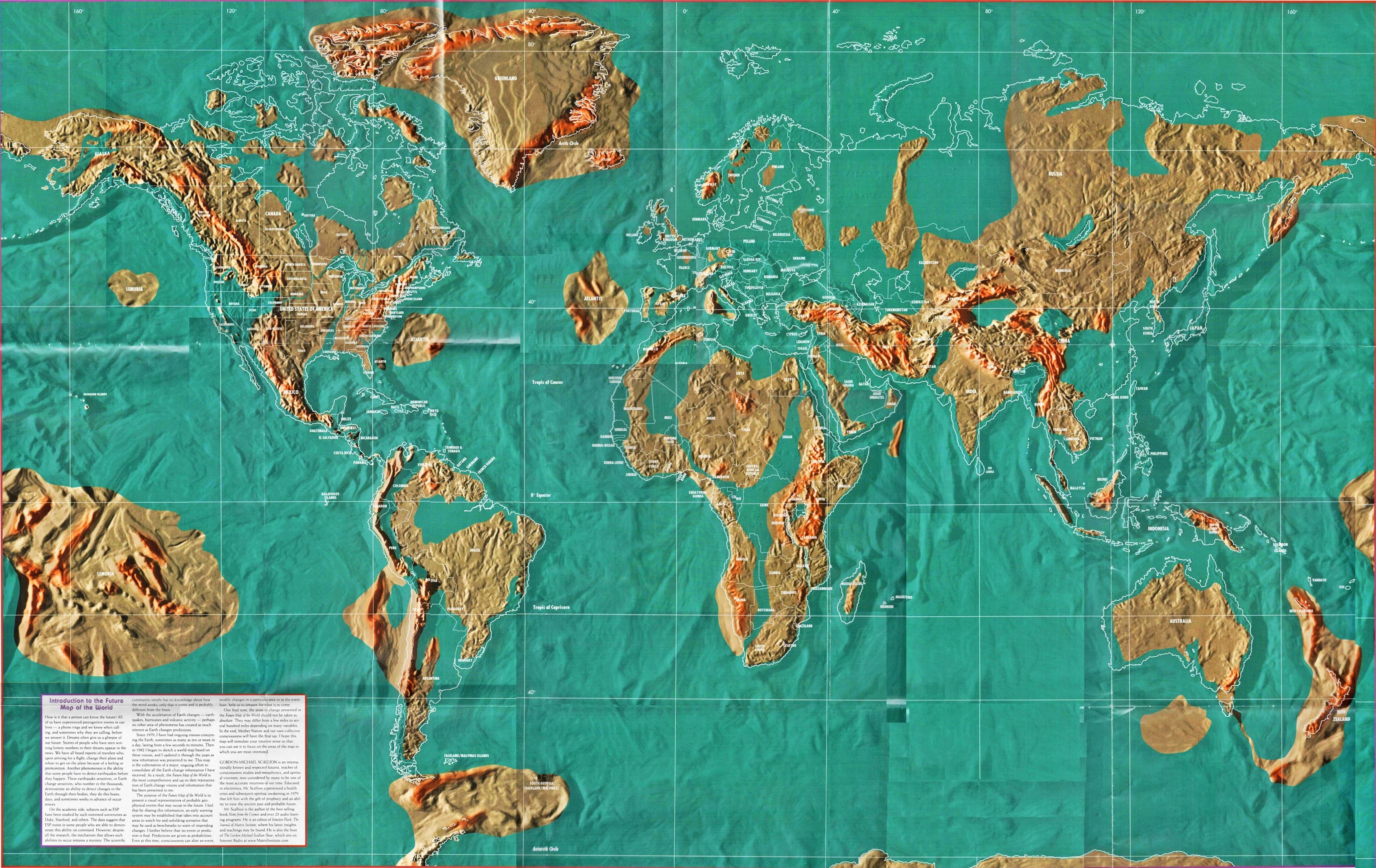
Image source: Crystalinks
Before we can judge the value or absurdity of doomsday clocks, or in this case, maps, it helps to understand why they’re made. These maps are usually based on what could happen if the worst-case outcomes become a reality. They often include massive flooding, disappearing coastlines, and new land masses rising from the sea. They’re not about precision, rather about possibility.

Image source: Aljazeera
The History and Purpose Behind Doomsday Cartography
Doomsday cartography isn’t new. Early maps featured lost cities like Atlantis or Lemuria. They were speculative and often tied to religious or spiritual beliefs. Over time, they evolved into visual projections that tried to show how the Earth might be reshaped by natural disasters or planetary changes.
These maps fall somewhere between warning and fantasy. They help people visualize collapse, whether from a scientific perspective or a clairvoyant one. Some are simple overlays on a world map. Others are complex projections about everything from tectonic shifts to submerged continents.
How Futurists Like Edgar Cayce Influenced Apocalyptic Mapping

Image source: Unsplash
Edgar Cayce was one of the early influences in this space. Known as a prophet and psychic, Cayce predicted massive geological changes. He warned of a polar shift, earthquakes, and floods that would reshape continents. In his view, these weren’t distant risks, they were coming very soon.
Cayce’s forecasts were based on trance states, not instruments or measurements. Still, he developed a following. Many of the catastrophe maps of the world created later borrowed from his ideas. Some even directly referenced his forecasts for the United States, including new inland seas and the reappearance of Atlantis.
The Science vs. Speculation in Catastrophic Earth Changes
There’s a sharp line between what scientists predict and what psychics claim. Climate scientists build models based on data, melting ice caps, ocean temperature trends, and historical sea level changes. The result: detailed, evidence-based possibilities showing gradual change.
Apocalyptic maps skip the slow buildup. They assume dramatic, sudden events: the sea rises hundreds of feet, earthquakes split continents, volcanoes reshape coastlines. These situations are not impossible, but they’re not backed by current geological trends either.
They don’t reflect actual science, they reflect fear, faith, or both.
Who is Gordon-Michael Scallion and What Do His Future Maps Show?
Most preppers who have heard of such maps know the name Gordon-Michael Scallion. He gained attention in the 1990s for publishing future maps based on prophetic visions. His projections were detailed and specific, especially when it came to how North America might change after a global cataclysm. Whether you think of him as a spiritual guide or a pseudoscientist, his maps sparked plenty of discussion and still do.
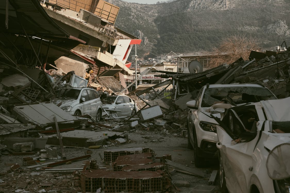
Image source: Doruk Aksel Anıl_Pexels
Gordon-Michael Scallion's Background and Clairvoyant Projections
Scallion wasn’t a scientist, unlike some think. He described himself as a spiritual visionary and teacher of consciousness studies. After a medical event in the 1970s, he claimed he began receiving visions of future Earth changes.
Over the years, Scallion issued several maps. Each one reflected a timeline of dramatic Earth changes, many of them triggered by a polar transition or deep tectonic instability. These weren’t minor changes; entire countries disappeared, new land masses appeared, and inland areas turned into coastlines.
Analyzing Scallion's Disaster Map of North America
Scallion’s disaster map of North America is probably his best-known work. It shows California mostly gone, with the Pacific Ocean pushing far inland and Florida disappearing. The East Coast is flooded into Pennsylvania while the Great Lakes expand southward, linking with the Gulf of Mexico.
According to Scallion, seismic activity and volcanic eruptions would trigger flooding that turns parts of the Midwest into an inland sea. The Rocky Mountains remain, but the area surrounding them becomes coastline.
In this version of the future map, Colorado becomes a waterfront state, as does Nebraska. The projection includes a new inland sea reaching well into the central United States. Coastal areas are entirely wiped out.
Timeline of Scallion's Global Projections
Scallion never gave fixed dates for these events. Instead, he spoke of a timeline that began with escalating natural disasters, earthquakes, floods, and weather extremes, followed by a polar transition. He described a series of visions in which tectonic activity led to rapid, global reshaping.
Scallion’s forecasts included Earth to turn blue again, with water covering much of the current land mass. It wasn’t a slow process, he framed it as a cataclysmic event.

Image source: NASA_Unsplash
How Would Rising Ocean Levels Transform America According to Scallion's Maps?
One reason Scallion’s maps got so much attention is because of how drastically they change the shape of the United States. Cities vanish. New coastlines form, and states that are landlocked now become beachfronts, according to him.
In this section, we look at how these maps imagine the future geography of North America, especially if ocean levels rise after a polar transformation or other Earth changes.
Coastal Flooding Forecasts and Major Cities at Risk
In the shocking future maps, cities like New York, Los Angeles, and Miami are already gone. The sea inundated coastal areas in both directions. These maps show inland flooding stretching deep into the country.
Scientific models of climate change do show ocean level increase, but it’s measured in feet, not the hundreds of feet required to produce Scallion’s map of North America. Still, both versions agree on which coastal zones are most exposed.
The Future of the Great Lakes Region in Cataclysmic Prophecies
Scallion’s forecast turns the Great Lakes into the edge of a much larger inland sea. Earthquake activity expands existing water bodies, and a polar transition redirects ocean water into the central U.S.
This new water body runs through Illinois, Missouri, and into the South. It cuts the country in half, turning what was once landlocked territory into a channel between two coasts.
How Colorado and Inland Areas Might Become Coastal in Polar Transition Theories
Scallion predicted that if a polar change happened, the terrain in the western United States would collapse along fault lines. As a result, water from both the Pacific and Gulf of Mexico would move inward.
Colorado, currently protected by the Rockies, becomes coastal, and so does Kansas. The inland sea stretches north to the Great Lakes and south to the Gulf. This inland transformation is one of the key ideas in Scallion’s future map.
What Global Regions Are Most Threatened in Apocalyptic Map Projections?
Scallion and others did not limit their predictions to North America. Their maps include changes across every continent. Some regions lose land while others gain it. The global reshuffling is often based on tectonic activity, earthquake zones, and ideas about land masses rising from beneath the sea.
These predictions are sweeping and sometimes bizarre but always aimed at answering the same question: What would a major global disaster do to the Earth’s surface?
South America Transformations in Shocking Doomsday Predictions
In many of these maps, South America is torn apart. The Andes Mountains collapse, and parts of the western coastline fall into the Pacific. Northern Brazil floods. Furthermore, an inland sea forms in the center of the continent.
The map of South America becomes thinner. It’s a familiar pattern in apocalyptic maps: coastal areas vanish, and inland regions are restructured by floodwaters and tectonic movements.
The Potential Return of Atlantis: Predictions About New Landmasses
Some maps include lost continents. Atlantis, for instance, is shown rising from the Atlantic. Others feature Lemuria, appearing in the Pacific near Asia.
These aren’t grounded in geology, but they’re recurring features in dystopian maps of the world. They represent a reset, where old land returns and current continents lose space.
How Volcanic Activity and Earthquakes Figure into World Map Changes
Volcanic activity plays a big part in these predictions, too. Earthquakes trigger fault line collapses, and volcanoes erupt across the Pacific Rim, Japan, and Indonesia. According to this theory, some islands will vanish while new ones will form.
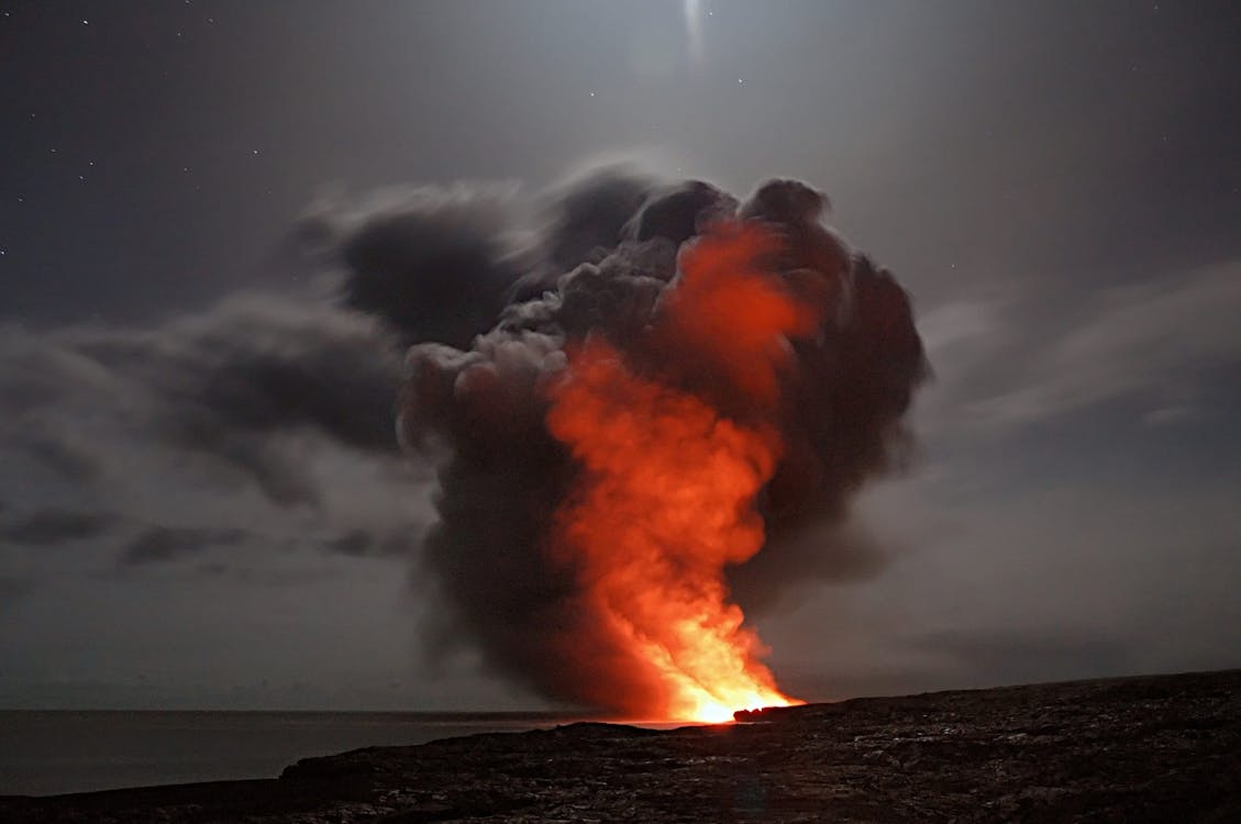
Image source: Pixabay_Pexles
In the more extreme maps, Antarctica becomes habitable again as ice melts and volcanic heat reshapes the region. However, these predictions rely heavily on geological stress and chain-reaction thinking.
Are Billionaires Creating Escape Plans Based on End-of-the-World Maps?
It sounds like a conspiracy theory until you look at real headlines. Wealthy people have been buying remote properties, building underground bunkers, and planning for events that look a lot like end-times map predictions. While most people do not take Scallion’s future map seriously, some of the same “safe zones” he suggested now have high-interest real estate, especially from the ultra-rich.
Examining Billionaire Escape Plans and Bunker Locations
The phrase world and the billionaire escape has gained traction in forums and media. The idea is that while the rest of the population faces disaster, billionaires use hidden resources to relocate to safe zones.
These zones often match regions that Scallion’s map left untouched such as parts of Canada, the Rocky Mountains, and New Zealand.
How the Wealthy Are Preparing for Predicted Earth Changes
Some reports mention underground facilities, private runways, or even remote compounds in regions far from cities. These aren’t linked directly to Scallion, but the overlap is there. Whether it’s climate risk, social unrest, or polar change predictions, the logic behind these billionaire escape plans echoes themes found in apocalyptic maps.
How Do Modern Scientific Projections Compare to Prophetic Doomsday Maps?
The topic of discussion changes at this point. The aims, methodologies, and data sources of science and speculation are radically different. Here, we contrast the more scientifically grounded projections of future sea levels with the more mystical end-of-the-world prophecies found in this cartography. As a result, it is easier to tell what is based on evidence and what isn't.
Global Warming Ocean Level Rise Models vs. Apocalyptic Maps
The melting of Greenland and Antarctic ice caps is the basis for modern scientific forecasts of a rise in ocean levels due to climate change. Extreme weather events, such as continental floods, are not predicted by these models.

Image source: Pexels
However, the scientific warnings are serious. Regular flooding is already a problem in places like Venice, Jakarta, and even some parts of Florida. In addition, there has been an uptick in coastal flooding. However, the magnitude and velocity are dissimilar. Prophetic visions foretell a catastrophic disaster. Projections made by scientists outline a procedure.
Future Sea Level Maps: Separating Scientific Projections from Apocalyptic Visions
There is no scientific basis for these end of times maps. These theories are based on visual representations of ideas, conjecture, and the worst-case scenario. That renders them inaccurate but captivating all the same. They mirror the way humans deal with ambiguity, particularly when it relates to changes that are beyond anyone's control or projection.
The North American future map drawn by Gordon-Michael Scallion looks radical and is similar to a lot of other maps. Still, they manage to keep people's attention by making them consider the larger picture: What would happen if the earth were to move, the ocean level were to rise, and the familiar map of the planet were to become irrelevant?
Science provides its solutions based on facts, gradual patterns, and calculated forecasts. However, there will probably always be a chasm between these two points of view. Neither the practice of mapping out apocalypse outcomes nor the forecasts themselves are going anywhere.
Frequently Asked Questions